Showing posts with label cell phones. Show all posts

Tuesday, October 2, 2012

Mobile Devices Offer Fast Decisions, Productivity, Official Says


By Claudette Roulo
American Forces Press Service

WASHINGTON, Oct. 2, 2012 – Mobile devices are becoming the way we communicate, and the Defense Department views that change as an opportunity, the department’s deputy chief information officer for command, control, communications and computers and information infrastructure said Sept. 28.

Air Force Maj. Gen. Robert E. Wheeler told American Forces Press Service and the Pentagon Channel that National Cyber Security Awareness Month is a good time to consider what is involved in adopting mobile communications.

"There's always risks involved in having a mobile strategy where you're not connected directly to the network," he said.

The Pentagon’s mobile device strategy released in June outlines DOD’s plan to maximize the potential uses of mobile devices. The plan covers three key areas: wireless infrastructure, mobile devices and mobile applications. According to the CIO website, the goal is to keep these areas flexible and secure enough to benefit the warfighter and keep pace with changing technology.

Wheeler said the CIO’s mobile implementation plan will be released by mid-October. The plan will consolidate the results of about 21 pilot programs to create a mobile device plan to apply across the enterprise. This will provide the ability to "think and acquire data [from] different directions -- voice, video and data," he said, and is another step toward unified requirements for use of all parts of the DOD network.

"So, instead of having multiple different kinds of ways … of connecting to the network,” the general said, “we're going to have an enterprise-type model that actually buys down the risk" and that ultimately will give DOD a better understanding of problems and the ability to make decisions at a faster pace.

The mobility implementation plan is a way for DOD to take advantage of where the rest of the world is going with mobile communications, Wheeler said.

“So, for example, if we do this in an enterprise-type model,” he added, “we can go cheaper, we can buy down the risks, … [and] we can jump the productivity curve."

The ability to make decisions while on the move versus deciding and then moving is a big change from a DOD perspective, Wheeler said. That process is being adopted more frequently in small pockets around the DOD, he added, “but now this would be an enterprisewide approach to doing business in a particular way, and it allows everyone to do this while on the move."

DOD has several objectives as the CIO shapes mobility strategy, Wheeler said. Saving money and increasing security are important, he said, but the key objective is less quantifiable.

Young people understand the power of apps and how to use them, he said, but for "digital immigrants" like him, it's a bit more difficult to adapt. But doing so could change the way DOD operates, allowing the department to move faster, make decisions faster, stay ahead of adversaries, and make better business decisions.

"I think this is the key piece to it,” Wheeler said. “So we save money [and] we increase the security, but the big power down there is jumping the productivity curve so we can do many more things faster and actually provide more time for our people to think -- to do those things that they need to get done and to make those right decisions."

But, he noted, if the cybersecurity thread is lost at any point, DOD also will lose productivity and the cost becomes an irrelevant issue, because security breaches have the potential to be devastating on a national level. So, Wheeler said, DOD has established three categories of devices that will move through the approval process.

The first category includes devices that never need to connect to a DOD network, he said. An example of those types of device might include tablets to replace the knee boards used by pilots to hold their paper checklists and charts. Pilots could download updated information through a commercial Internet connection set up specifically for that purpose.

The second category would cover mobile devices that connect to the unclassified network, including commercially available devices such as the iPhone or Android devices. “That's a group of devices that will be approved, and in fact, that's going through the process right now,” Wheeler said.

The third category is for devices that connect to the classified network. Some of those devices will meet the security requirements to allow them to connect directly to a classified network, he said, while others will encode classified information in such a way that it can travel on commercial networks.

For average users, this means that the capabilities of today’s mobile devices will be available to them while at work on either classified or unclassified networks, Wheeler said. That capability includes the ability for all approved devices to download required apps from a DOD app store.

Regardless of the type of device, a faster approval process is a key part of the implementation plan, Wheeler said.

"Historically, DOD has been slow to approve electronic devices. … If you see how the market works, in 12 to 18 months that device is no longer even available, so we have to be able to approve it."

To make sure devices can be approved quickly, he said, the CIO took a two-pronged approach: They provided mobile device makers with DOD's security requirements, and they incorporated a mandatory timeline into the approval process. Wheeler cited the specific example of the planned DOD app store.

"We're requiring that if somebody needs an app for their specific mission, they provide it and [we respond] within 90 days," he said. The applicant receives an approval or a denial, or is told that certain changes are required to the app before it can be approved.

One of the main reasons for adopting the timeline was security, the general said. "As new technology comes out we need to take advantage of that new technology and move with that new technology to keep our stuff more secure,” he explained. “So, waiting two, three, four years to approve something is something that would actually hurt our ability to do the mobility implementation plan."

Eventually, the CIO would like to reach the point at which mobile devices are approved for use on the network before they're even released, he said. That way, he added, devices that meet the security requirements could be put into use as soon as they're available.

"At the end of the day,” Wheeler said, it becomes an issue of the individual user understanding the rules [and] following those rules -- not trying to push the envelope and saying, 'Well, I want this specific app' is a prime example of that -- one that doesn't come off the approved list of apps and trying to put that on their phone."

It's incumbent upon everyone to make sure that they're watching how they operate, Wheeler said, both from a cybersecurity perspective and from an operational security perspective. And that's something that isn't just about mobile strategy, he added, but about how DOD does business as a whole.

Monday, September 17, 2012

New "ATM" Takes Old Phones and Gives Back Green


Using sophisticated artificial intelligence, kiosks evaluate unwanted tech for resale and recycling

When new cell phones or tablets enter the marketplace, yesterday's hot technology can quickly become obsolete--for some consumers. For others, the device still has value as an affordable alternative, or even as spare parts.

With support from the National Science Foundation (NSF), ecoATM of San Diego, Calif., has developed a unique, automated system that lets consumers trade in those devices for reimbursement or recycling.

Using sophisticated artificial intelligence developed through two NSF Small Business Innovation Research grants, ecoATM kiosks can differentiate varied consumer electronics products and determine a market value. If the value is acceptable, users have the option of receiving cash or store credit for their trade--or donating all or part of the compensation to one of several charities.

ecoATM finds second homes for three-fourths of the phones it collects, sending the remaining ones to environmentally responsible recycling channels to reclaim any  rare earth elements and keep toxic components from landfills. ecoATM is certified to the eWaste environmental standards of Responsible Recycling (R2) and ISO 14001.

"The basic technologies of machine vision, artificial intelligence and robotics that we use have existed for many years, but none have been applied to the particular problem of consumer recycling," says ecoATM co-founder and NSF principal investigator Mark Bowles. "But we've done much more than just apply existing technology to an old problem--we developed significant innovations for each of those basic elements to make the system commercially viable."

ecoATM received its first NSF support in 2010, then received follow-on funding from Coinstar, Claremont Creek Ventures and Silicon Valley Bank to launch the first kiosks in 2011. The company expanded to the Washington, D.C. metropolitan area and other areas along the East Coast this month and plans to have more than 300 kiosks deployed by the end of 2012 in shopping malls and large stores across the country.

The system began as a wooden-box prototype that required the presence of an ecoATM representative to ensure that users were being honest with their trades. While that setup proved consumers would be comfortable with the device-exchange concept, it was limited by the need for human intervention.

The first NSF Small Business Innovation Research grant allowed ecoATM to develop artificial intelligence and diagnostics that delivered 97.5 percent accuracy for device recognition, removing human oversight and making the system viable for broad use. A follow-on NSF SBIR grant is helping ecoATM close that final 2.5 percent accuracy gap.

According to Bowles, traditional machine vision generally relies on pattern matching, pairing a new image to a known one. Pattern matching is a binary approach that cannot handle the complexity of ecoATM's evaluation process, which includes eight separate grades based on a device's level of damage.

"We are now able to tell the difference between cracked glass on a phone, which is an inexpensive fix, versus a broken display or bleeding pixels, which is generally fatal for the device," says Bowles. "We were warned by leading machine-vision experts that solving the inspecting/grading problem-with an infinite variety of possible flaws-was an impossible problem to solve. Yet with our NSF support, we solved it through several years of research and development, trial and error, use of artificial intelligence and neural network techniques."

The company's databases are now trained with images of more than 4,000 devices, and when an identification mistake occurs, the system learns from that mistake.

When a user places their device into an ecoATM kiosk, the artifical intelligence system conducts a visual inspection, identifies the device model and then robotically provides one of 23 possible connector cables for linking it to the ecoATM network (the company warns consumers to erase all personal data before recycling).

Using proprietary algorithms, the system then determines a value for the device based on the company's real-time, worldwide, pre-auction system.Within that system, a broad network of buyers have already bid in advance on the 4,000 different models in eight possible grades, so the kiosk can immediately provide compensation.

A number of robotic elements enable the kiosk to safely collect, evaluate and then store each device in a process that only takes a few minutes.

"The ecoATM project is an extremely innovative way to motivate the public with an incentive to 'do the right thing' with discarded electronics, both socially and environmentally," says Glenn Larsen, the NSF SBIR program officer overseeing the ecoATM grants. "This may change behavior from simply dumping unwanted electronics to a focus on recycling, while helping put more hi-tech devices in the hands of others that might not otherwise be able to afford or acquire them."

The company is partnered with San Diego-based D&K Engineering to help design and build the kiosks domestically, and has expanded from an original workforce of less than 10 in 2010 to a team of more than 150 employees and contractors today.

Since its founding, ecoATM has filed over 20 patents, been awarded seven patents to date, and won numerous awards. The company is currently one of three finalists for a Consumer Electronics Association Inaugural Innovation Entrepreneur Award.

"ecoATM meets the required thresholds of both convenience and immediate financial incentive necessary to inspire mass consumer participation in electronics recycling," adds Bowles. "We believe we are the first system to achieve those thresholds."

 -NSF-

Tuesday, June 26, 2012

Bomb Threat? An App for that, too


Homeland Security’s new smartphone application for bomb threats

At approximately 6:30 pm on Saturday, May 1, 2010, a smoking SUV in Times Square was reported by alert street vendors. Acting quickly, NYPD evacuated vast stretches on 7th and 8th Avenues, including Broadway theatres and several other buildings and hotels in the area. The entire area was barricaded. Times Square on a Saturday evening before the shows is teaming with people, and the terrorist knew that. The bomb failed, but had it detonated, it would have killed and wounded many, according to NYPD.

In the first chaotic moments after suspicion of a bomb threat, first responders have a myriad of questions, assessments, and decisions to make, all at once, and all the while the scene could be changing rapidly. Is the bomb real? How large is the potential blast radius? Where will we evacuate people? Are there any critical infrastructure or special-needs population centers in the vicinity? Any schools, hospitals nearby? What roads should be closed? Which roads should stay open for evacuees? And on and on....

What if they could get all this information in one place?

Now they can: The U.S. Department of Homeland Security's (DHS) Science and Technology Directorate (S&T) and its public and private sector partners have developed a must-have "app": the First Responder Support Tools (FiRST) for computers and smartphones.

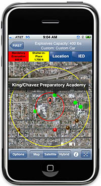
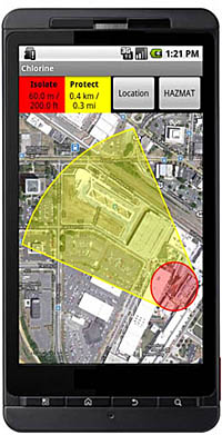
The FiRST application was developed in partnership with the DHS National Protection and Programs Directorate's (NPPD) Office of Infrastructure Protection (IP) along with its Office for Bombing Prevention (OBP), and Applied Research Associates, Inc. (ARA). The FiRST app provides information directly to first responders on their smartphones or laptop computers in order to quickly define safe distances to cordon-off around a potential bomb location, calculate rough damage and injury contours, suggest appropriate roadblocks, determine when mandatory evacuation or shelter-in-place circumstances apply, and to identify nearby areas of particular concern: schools, hospitals, care centers. The application also provides the geospatial information regarding potential injury, glass, or structural damage impact area.

"That's why it works," said Christine Lee, FIRST program manager in S&T's First Responders Group. "Bomb threat scenarios do not reflect a one-size-fits-all approach, and this app allows users to customize information to help them make informed decisions for response."

The FiRST application also includes HAZMAT response information based on the Emergency Response Guidebook (ERG) which includes information on over 3,000 hazardous materials. In addition to providing health precautions and response guidance, FiRST also retrieves current and forecast weather to show downwind protection zones for over 600 materials that are inhalation hazards.

FiRST is available to first responders for a nominal fee (about $12 for mobile devices and $100 for Window PC version).  The app will be of interest and applicable to anyone who might need to address a potential bomb or HAZMAT spill response, such as industry, HAZMAT transport, or security personnel.  HAZMAT information is available to all users.   Specifically defined DHS bomb standoff data is considered sensitive and is automatically made available to those that register the application with a .gov, .mil, or .us email address. Users without a .gov, .mil, or .us email address can be approved for access on a case-by-case basis in coordination with the Office of Bomb Protection.   (However, any user can input into the app and define his own custom bomb and standoff distances, which might be applicable to certain jurisdictions and/or localities.) 

The FiRST app uses services readily available with current smartphones: email, phone, Google Maps, Google Search, and weather and road network data. "We use existing hardware that responders are already familiar with because responders can't waste time navigating a complex interface during the chaos of an incident," said Carl Jerrett, ARA program manager. "No longer will they have to carry additional tools such as hard-copy blast standoff guidance cards, rulers, or maps." Sergeant Thomas Sharkey, the District of Columbia Metro Transit Police Bomb Squad Commander, said "Unlike other confusing software on desktop computers, this application is easy to purchase, easy to install, and even easier to use."

Once a first responder enters a general definition and location of the bomb or HAZMAT incident into the FiRST app, the results are instantaneous. They can run a roadblock analysis to identify which roads are best suited for closure in order to isolate a bomb threat within that specific region. Google Search features are available to identify and display locations where increased numbers of the public may be at potential risk. "FiRST allows responders to label a map with critical information, and this information not only helps first responders better understand an incident, but these maps can then be shared with other responders," said Jerrett. Users can quickly send results to colleagues via email, which includes a text summary, a map image, and GIS file attachments that are viewable in applications like Google Earth or WebEOC¨.

The FiRST app is available for iPhones and iPads, Androids, and Windows personal computers. The application is available for purchase at a nominal fee on iTunes, the Google Play, and ARA's e-commerce website.

FiRST field evaluations were conducted last year by the Washington Metropolitan Area Transit Authority, bomb squad, police, EMT, firefighter, and hazmat units. United States Secret Service personnel observed the evaluations as well. After the application testing and evaluation phases were completed, Sharkey said, "This app is a must-have for bomb technicians and first responders."

Tuesday, June 19, 2012

Emergency Alerts straight to your Cell Phone


Questions and Answers about the new service

(MADISON) –  Local and State Emergency officials and the National Weather Service will have another tool for alerting the public to dangerous conditions - called Wireless Emergency Alerts (WEA). These emergency alerts will be sent to newer cell phones in affected areas. Alerts will continue to be issued or available on other sources including radio/TV stations, on NOAA Weather Radios and local sirens. 

Due to unforeseen connectivity issues, the rollout will de delayed until Wednesday June 27, 2012. Those issues are being solved right now but officials want extra time to test the new system.

Because this system is so new, people have many questions about how it works. Here are some commonly asked questions and answers.

1. What are WEA messages? Wireless Emergency Alerts (WEA) are emergency messages sent by authorized government alerting authorities through your mobile carrier. Government partners include local and state public safety agencies, Federal Emergency Management Agency, the Federal Communications Commission, the Department of Homeland Security and the National Weather Service.

2. Does WEA replace other warning systems? No. WEA is not a replacement for other warning systems. It is part of the nation's larger warning network and is only intended to act as a bell ringer, so people should continue to rely on traditional sources for emergency information such as TV/radio, NWR, and community warning systems.

3. Why is this important to me? Alerts received at the right time can help keep you and your family safe during an emergency. With WEA, alerts can be sent to your mobile device when you may be in harm's way.

4. How do I know if my phone will receive WEA messages? The NWS is expected to send selected weather-related warnings to WEA-capable devices starting June 27, 2012. But many mobile devices, especially older ones, are not WEA-capable. When you buy a new mobile device, it probably will be able to receive WEA messages. For information about which mobile devices are WEA-capable, please visit http://www.ctia.org/wea or contact your wireless carrier.

5. Do I have to sign up for WEA service? No, consumers will not have to sign up for WEA messages. They will be automatically broadcast to all cell phones with WEA capability in the warning area.

6. Do I have to download an app? No, you do not need to download an app or subscribe to a service.

7. Will I be charged for receiving WEA messages? No. This service is offered for free by wireless carriers. WEA messages will not count towards texting limits on your wireless plan.

8. What types of alerts will I receive?

• Extreme / life threatening weather warnings
• Local emergencies requiring evacuation or immediate action
• AMBER Alerts
• Presidential Alerts during a national emergency

Of the 4 types of alerts, extreme weather warnings from the National Weather Service, by nature, will be the most frequent.

9. Does WEA know where I am? Is it tracking me? No. WEA messages go to all the cell phone towers in the affected area. If your phone is receiving a signal from one of those towers you will get the message.

10. Will I receive a WEA message if I'm visiting an area where I don't live, or outside the area where my phone is registered? Yes, if you have a WEA-capable phone and your wireless carrier participates in the program. For information about which mobile devices are WEA-capable and carrier participation, please visit http://www.ctia.org/wea or contact your wireless carrier.

11. What if I travel into a threat area after a WEA message is already sent? If you travel into a threat area after an alert is first sent, your WEA-capable device will receive the message when you enter the area.

12. What does a WEA message look like? WEA will look like a text message. The WEA message will show the type and time of the alert, any action you should take, and the agency issuing the alert. The message will be no more than 90 characters and is intended to be just a notification. Here are some examples:

• “Tornado Warning in this area until 2:15 PM. Take shelter now. –NWS”
• “Flash Flood Warning this area until 3:30 PM. Avoid flood areas. Check local media. – NWS”

13. How will I know the difference between WEA and a regular text message? WEA messages include a special tone and vibration, both repeated twice.

14. What types of WEA messages will the National Weather Service send?

• Tornado and Flash Flood Warnings
• Blizzard and Ice Storm Warnings

Note: Until further notice, Severe Thunderstorm Warnings are not sent as a WEA message.

15. What should I do when I receive a WEA message? Follow any action advised by the emergency message. Seek more details from local media or authorities.

16. Is this the same service public safety agencies have asked the public to register for? No. Local agencies may have asked you to sign up to receive telephone calls, text messages, or e-mails. Example: Reverse 911 services. Those messages often include specific details about a critical event. WEA are very short messages designed to get your attention in an emergency situation. They may not give all the details you receive from other notification services.

17. How often is an individual WEA displayed? Each WEA is displayed only once. However, cell carriers are planning on re-broadcasting the original WEA at certain intervals. The interval (could range from every 5 minutes to perhaps every 20 minutes depending on alert type.

18. Will a WEA message interrupt my phone conversations? No, the alert will be delayed until you finish your voice or data session.

19. How often will I receive WEA messages? You may receive frequent WEA messages during an emergency. Message frequency depends on the number of imminent threats to life or property in your area.

20. If, during an emergency, I can't make or receive calls or text messages due to network congestion, will I still be able to receive a WEA message? Yes, WEA messages are not affected by network congestion.

21. What if I don't want to receive WEA messages? You can opt-out of receiving WEA messages for imminent threats and AMBER alerts, but not for Presidential messages. To opt out, please refer to instructions from your wireless carrier or visit http://www.ctia.org/wea for more information.

22. How will I receive alerts if I don't have a WEA-capable device? WEA is one of many ways you can receive emergency notifications. Other sources include NOAA Weather Radio, news media coverage, the Emergency Alert System on radio and TV broadcasts, social media, and other alerting methods offered by local and state public safety agencies. Your best use of WEA is to immediately seek additional information about the imminent threat impacting your area.

23. Are WEAs the same as text messages? No. WEA are not the same as text messages. WEA will not have to be opened like SMS text messages, but will “pop up” on the device’s screen.

24. Will there be a delay in my cell phone receiving a WEA due to congestion since cell phone usage goes up in areas experiencing severe weather? No. Network congestion is not expected since each WEA is a radio broadcast rather than a text message (SMS).

For more information, go to http://readywisconsin.wi.gov and click on our “Cell Phone Alert” tab.